I found the map while looking for old visual records of Long Beach Island, expecting something simple.
Street names. Landmarks. Maybe a few town labels. Maybe something I could compare directly against the Surf City we walk through now.
What I found instead was stranger and better.
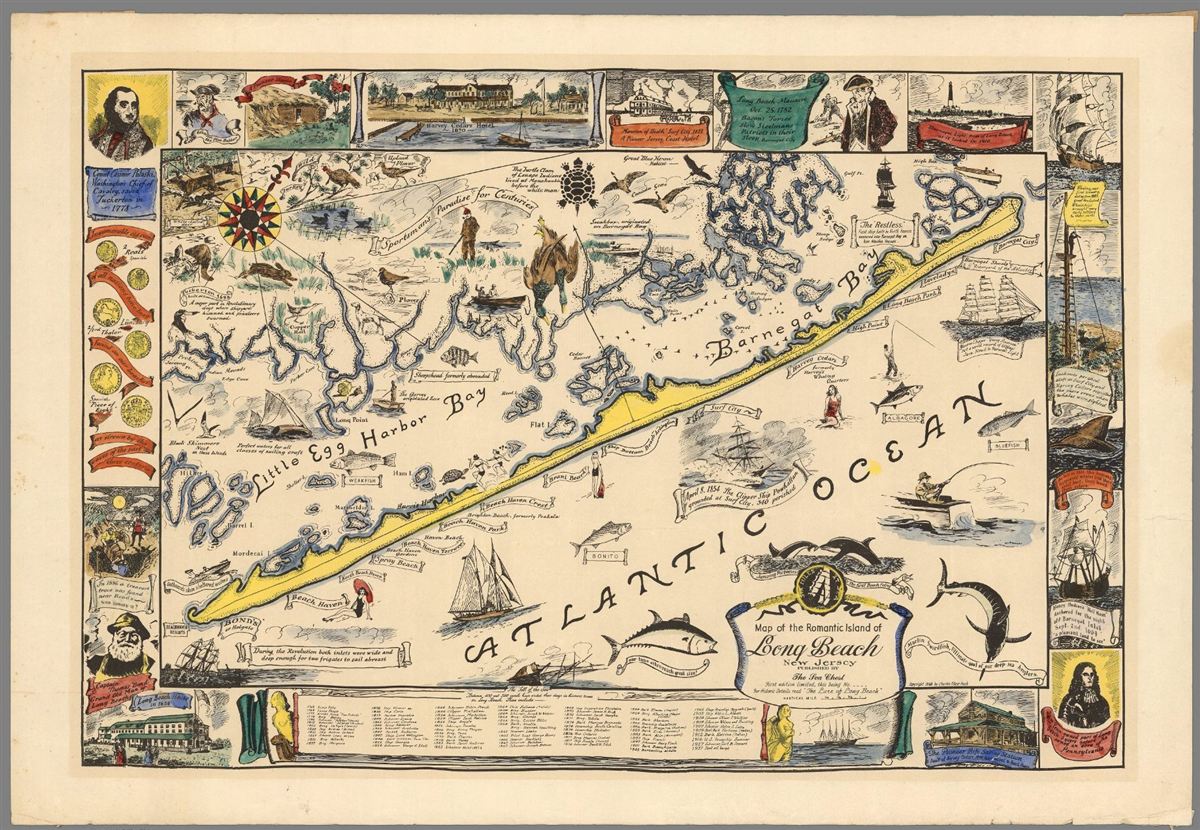
Charles Edgar Nash’s 1940 map of Long Beach Island is not really a blueprint in the modern sense. It is part map, part memory object, part love letter, part local-history collage. It shows the island’s geography, but it also crowds the edges and empty spaces with ships, fish, hunters, old hotels, colonial notes, local legends, and a chronology of vessels lost off Long Beach Island’s waters. A restored edition describes it as first printed in 1940 and filled with LBI geography, early colonial history, and a shipwreck chronology.
That matters, because once you stop looking at it like a modern road map, it starts telling a better story.
This was not the kind of map you use to find a lot line.
It was the kind of map you use to understand what a place thought was worth remembering.
It was the kind of map you use to understand what a place thought was worth remembering.
And in the middle of it, almost modestly, there is Surf City.
Not screaming for attention. Not drawn as a fully built-out summer grid. Just sitting there on the narrow yellow strip of Long Beach Island, with the bay on one side, the Atlantic on the other, and a long history tucked beneath a name that now feels so natural we forget it was ever chosen.
That is what pulled me in.
Because Surf City in 1940 was not just “old Surf City.”
It was Surf City caught between eras.
The old resort identity had not completely disappeared. The railroad age had just ended. The automobile age was taking over. The bay side was becoming more organized. The Boulevard was beginning to carry the shape of the island we know today. And somewhere beneath all of that was an even older place, one remembered through names like Old Mansion, Mansion Cove, Buzby’s Place, and Long Beach City.
The map does not reveal one lost town.
It reveals a town in transition.
Before Surf City was Surf City
Surf City sounds inevitable now.
It is one of those names that feels like it must have always been there. Simple, breezy, obvious. A shore-town name with enough charm to survive generations of beach badges, rental weeks, bikes, bay sunsets, and Boulevard traffic.
But Surf City was not always Surf City.
The place carried older names first. In the nineteenth century, this stretch of Long Beach Island was associated with the Great Swamp, Buzby’s Place, Old Mansion, and Long Beach City. Bay Magazine’s local-history account places the Mansion of Health along the southern edge of the Great Swamp, notes that the name Long Beach City was selected in 1875, and explains that Surf City was selected in the 1890s as the community formalized its identity.
The civil record gives the legal spine of the story: present-day Surf City was incorporated as Long Beach City on September 19, 1894, then renamed Surf City on May 26, 1899.
That name change was not just branding. It was practical.
George B. Somerville’s 1914 The Lure of Long Beach says the original name, Long Beach City, caused confusion because of its similarity to Long Branch, especially with mail, freight, and express shipments.
I love that detail because it makes the town feel less frozen in nostalgia and more alive.
Names were not just romantic. They had to work. A town name had to move through postal routes, railroad schedules, freight handling, summer correspondence, hotel bookings, and mainland memory. Long Beach City may have sounded grand, maybe even ambitious, but it was too easy to confuse.
Surf City was cleaner.
Shorter.
Harder to mistake.
And by the time Nash drew his 1940 map, that newer identity had settled in. The map does not label the town as Long Beach City. It labels it as Surf City. The old name was gone from the surface, but not from the story.
That is the first thing the map teaches if you sit with it long enough:
Surf City was already modern enough to have shed its old name, but old enough that the layers underneath had not vanished.
The old heart was not the Boulevard
If you only know Surf City today, it is easy to imagine the town beginning with its familiar north-south spine.
Long Beach Boulevard.
Central Avenue.
The numbered streets.
The short walk east to the beach or west to the bay.
But the older emotional center of Surf City was not the Boulevard.
It was the Mansion story.
The Mansion of Health was one of the earliest great hospitality landmarks on this part of the Jersey Shore. Local accounts place it near what became Surf City, and Somerville calls it the pioneer of Long Beach hostelries. He writes that it was built near the present site of Surf City because its founders believed the location, the point of land farthest east on the island, was the most healthful.
That phrase stops me every time: the most healthful.
Before Surf City was sold as a beach town, before it became part of the modern LBI rhythm, before summer traffic and rentals and restaurants and surf shops, this place was understood through air, exposure, wind, water, and health.
That is a different kind of origin story.
Not louder.
Maybe better.
Bay Magazine’s account says the Mansion of Health was built in 1821, the area around it became known as Buzby’s Place, and after the hotel burned in 1874, the people living around what was also called Old Mansion wanted their own identity. That led into the Long Beach City name, and eventually Surf City. The same account notes that the cove along the bay at 1st Street is often referred to as Mansion Cove.
That gives you a real place to stand.
Not just “somewhere in old Surf City.”
South 1st Street. Bay side. Mansion Cove.
Today, you can walk near that area and still be close to one of the oldest identity layers in Surf City. Not the surf-shop version. Not the rental-house version. Not the version you pass through in traffic without thinking.
The older version.
The health-resort version.
The Old Mansion version.
And once you know that, the town feels different. A simple street corner starts carrying more weight. A bayfront cove becomes more than a quiet view. It becomes evidence that Surf City has always been more layered than it looks.
The railroad was gone, but its ghost was still there
The second story hiding inside the 1940 map is the railroad.
By the time Nash drew Long Beach Island in 1940, the railroad era had just ended. The Long Beach Railroad ran north and south on LBI for 49 years, from 1886 to 1935. Bay Magazine makes the connection plainly: the railroad is responsible for much of the island’s geography today, including the widened roadway sections people still notice in Ship Bottom and Surf City.
That is the kind of fact that changes how you see a road.
Because once you know it, the Boulevard stops feeling like just a modern traffic corridor. It starts feeling like an inheritance.
Somerville’s 1914 account describes how the railroad line divided at Barnegat Junction, with one spur extending northward through Surf City, Harvey Cedars, High Point, and Club House toward Barnegat City, while another ran south through Ship Bottom, Brant Beach, Beach Haven Crest, Spray Beach, and Beach Haven.
That puts Surf City right inside the rail logic of the island.
Not as a side note. As part of the northern spine.
And then the ending came fast.
A 1935 nor’easter damaged the rail connection to LBI, and Echoes of LBI describes the storm as the final blow to an already struggling railroad. The trestle that carried trains across Manahawkin Bay was torn apart, the automobile bridge was damaged, and the railroad never returned.
So Nash’s map sits in a very specific moment.
Not during the railroad age.
Not long after it.
Only five years after the end.
That timing matters.
Surf City in 1940 was no longer a railroad town in operation, but it was still a railroad town in shape.
That may be the strongest thing this map reveals. Not because Nash gives us a modern infrastructure diagram, but because the date forces us to look at Surf City as a place still carrying the outline of what had just disappeared.
The tracks were gone. The movement pattern remained.
The railroad had vanished from daily life, but not from the way the island arranged itself.
And you can still feel that today if you know what you are looking for. The widened sections. The long north-south pull. The sense that traffic, commerce, and memory all follow a path older than the cars using it now.
In 1940, Surf City had already lost its train.
But it had not lost the railroad’s skeleton.
The bridge made the modern town possible
The railroad shaped the island, but the automobile changed its future.
Before the automobile bridge, getting a car onto Long Beach Island was not simple. Somerville wrote in 1914 that, until then, there had been only two ways to get an automobile to Beach Haven: on a freight car or on a flatboat. The new bridge and road connection placed the island’s resorts on the automobile roads of the country.
It is hard to overstate how much that changed the imagination of the island.
The railroad brought people to stations.
The automobile let people spread out.
The railroad served a resort chain.
The car helped create the LBI we recognize now, a place of houses, blocks, driveways, short errands, Saturday turnover, and the long shared nervous system of the Boulevard.
By 1940, Surf City had already crossed that threshold. The town Nash drew was post-railroad, post-bridge, and moving deeper into the automobile era.
That is why the map feels so alive to me.
It is not just showing an old place. It is showing a place that had recently changed transportation systems, recently outgrown an old name, and was still small enough for all those changes to feel personal.
The bay was never background
There is another easy mistake modern visitors make with Surf City.
They think ocean first.
The beach gets the attention, and for obvious reasons. It is the public face of the town. It is where summer announces itself. It is where people measure the day by tide, wind, guards, flags, umbrellas, and that first view over the dune.
But Surf City was never only an ocean town.
It was always a bay-to-ocean town.
Somerville wrote that every resort on Long Beach Island was “doubly favored” by having the Atlantic Ocean in front and the broad expanse of Barnegat Bay behind, with fishing, safe sailing, bathing, and other forms of seashore recreation tied into that geography.
That line gets at something visitors understand physically before they can explain it.
Surf City is not just near the beach.
It is narrow enough that the town feels held between two waters.
The ocean gives it brightness, movement, sound, exposure.
The bay gives it softness, reflection, boats, marsh edges, sunsets, and a slower kind of life.
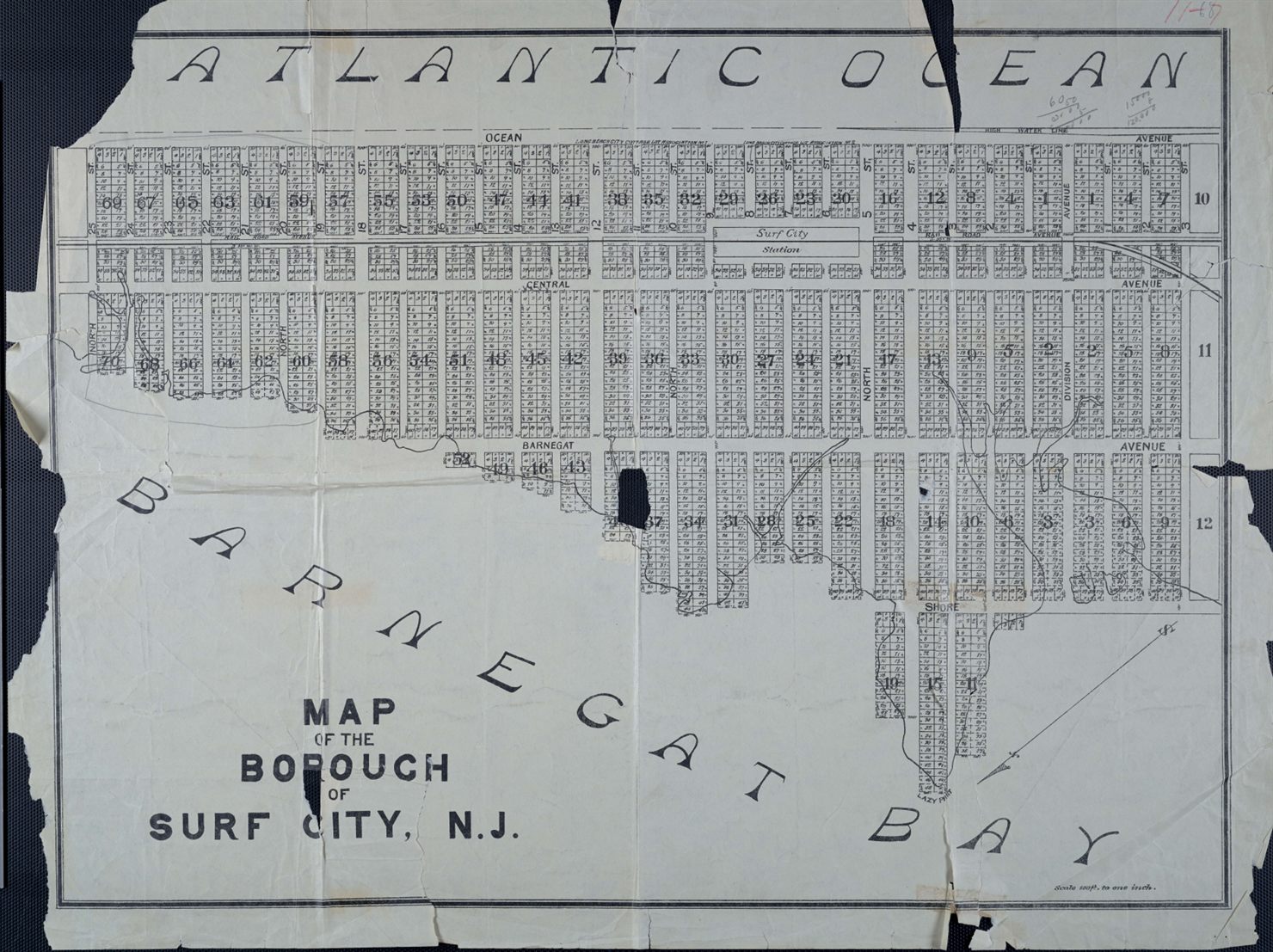
By 1940, that bay-side identity was becoming formal in a very specific way. The Surf City Yacht Club was founded in 1940 and is located today at 399 North 9th Street, on the bay side of Surf City.
That is one of the most useful anchors in the whole story.
North 9th Street. Bay side. 1940.
The same year as Nash’s map.
It gives the article a living hinge between the artifact and the town. While Nash was capturing Long Beach Island as a place of memory, recreation, history, and myth, Surf City’s bay culture was becoming organized at the neighborhood level.
If the ocean gave Surf City its public face, the bay gave it its rhythm.
And the town’s thinness made that rhythm unavoidable.
You could spend the morning in the surf and the evening watching the bay go silver. You could hear the ocean and still be thinking about boats. You could live in a town where crossing from one water to the other was not a journey, but a short walk.
That is not generic “shore lifestyle” copy.
That is geography shaping culture.
The map makes Surf City feel mythic. The census makes it feel intimate.
Old maps can trick you.
They make places feel bigger than they were because memory is generous. Illustrated maps especially do this. They compress time. They make legends, roads, shipwrecks, fish, towns, hotels, and entire eras sit beside each other on the same surface.
Nash’s map gives Surf City a place inside the romance of Long Beach Island.
But the population numbers bring the scale back down.
Surf City had 76 residents in 1930 and 129 in 1940, according to historical census figures.
That contrast matters.
The map makes Surf City feel mythic.
The census makes it feel intimate.
A town of 129 year-round residents is not the Surf City most summer visitors picture. It is smaller, quieter, more exposed, more seasonal, and probably more dependent on a handful of people doing the work that keeps a place alive.
The roads mattered.
The mail mattered.
The bridge mattered.
The bay mattered.
The old hotel memory mattered.
The name mattered.
Because in a small borough, those things are not abstractions. They are the bones of daily life.
And maybe that is why this map feels so compelling. It does not show us a fully finished Surf City. It catches Surf City while it is still becoming.
Old enough to have legends.
Modern enough to need roads.
Small enough that every layer still feels close to the surface.
What the 1940 map really reveals
The more I looked at Nash’s map, the less I wanted to use it as a simple then-and-now comparison.
That was my first instinct.
Find the old streets. Match them to new streets. Look for what disappeared. Build a clean visual comparison.
There is value in that, and Sanborn maps or tax records could take the research further. But the Nash map is doing something different.
It is not giving us a municipal survey.
It is giving us a memory system.
It shows Surf City as part of the larger romance of Long Beach Island, surrounded by stories of storms, wrecks, fishing, hunting, old resorts, historic movement, and island identity.
And when you place that map against the historical record, Surf City’s 1940 moment becomes clearer.
It was no longer Long Beach City, but the name-change story still explained something important about how shore towns had to define themselves.
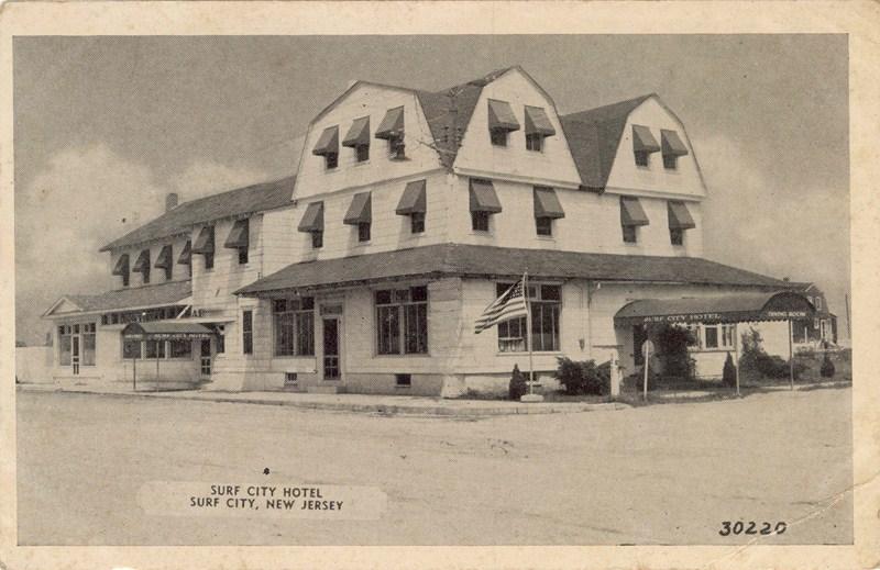
It was no longer the Old Mansion resort place, but Mansion Cove and the Surf City Hotel lineage still held that older memory.
It was no longer served by the railroad, but the Boulevard and widened roadways still carried the afterimage of the tracks.
It was no longer isolated the way it had been before the automobile bridge, but it had not yet become the fully built-out summer borough people recognize today.
It was an old place and a new place at the same time.
That is the heart of the article.
Not nostalgia.
Continuity.
Surf City did not become modern by erasing its earlier selves. It became modern by building over them, beside them, and sometimes directly through them.
Walking through Surf City now
The next time you cross Surf City from bay to ocean, the town looks different if you know what you are walking through.
South 1st still points back toward the Old Mansion story.
The Boulevard still carries the ghost of the railroad.
North 9th still speaks to the bay culture that was becoming formalized around the same moment Nash drew his map.
And the name Surf City itself, which feels so natural now, is really the surviving answer to an older identity problem.
That is what the 1940 map reveals.
Not a lost town exactly.
A town between eras.
A place shedding one version of itself while quietly becoming the one we still recognize.
And maybe that is why old maps matter so much.
Not because they show us everything perfectly. They do not.
They simplify. They decorate. They distort. They leave things out.
But sometimes they catch a place in the middle of becoming itself.
And if you are willing to look closely, they let you stand in the present and feel the older town under your feet.
And if you are willing to look closely, they let you stand in the present and feel the older town under your feet.
Sources and Further Reading
-
Charles Edgar Nash, 1940 map of Long Beach Island, David Rumsey Map Collection
davidrumsey.com -
George B. Somerville, The Lure of Long Beach, 1914
archive.org -
John P. Snyder, The Story of New Jersey’s Civil Boundaries: 1606–1968
archive.org -
Bay Magazine, “The Towns of Long Beach Island, Old and New”
bay-magazine.com -
Bay Magazine, “All Aboard”
bay-magazine.com -
Echoes of LBI, “The Last Train”
echoesoflbi.com -
Surf City Master Plan, 2008
surfcitynj.org -
Surf City Yacht Club
scyc-nj.org